
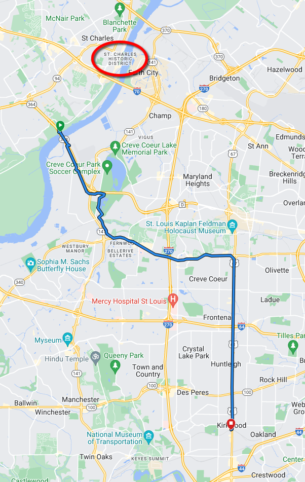
Bike Route: Katy Trail at 364 to Kirkwood Station
Status: This is all wrong, and I need to redo it. I need to ride the proposed route(s) at the bottom, and then redo this page.
This 16.86 mile route starts on the Katy Trail at the MO-364 / Creve Coeur Park Connector. This connector intersects the Katy Trail about 4.2 miles south-southwest of the St. Charles Trailhead. Therefore, if using this route to travel from the St. Charles Trailhead, the total distance will be about 21 miles. Starting GPS: 38.738486, -90.522968 (38°44'18.6"N 90°31'22.7"W)
The destination is the Amtrak station in Kirkwood, Missouri (110 W Argonne Dr, Kirkwood, MO 63122).
Much of this route follows Olive Blvd and Lindbergh Blvd, both of which are major thoroughfares in St. Louis County. They are not scenic, and they are not quiet. Parts of Lindbergh are divided highway with a fairly high speed limit.
Directions
0. From the Katy Trail St. Charles Trailhead, ride 4.2 miles south-southwest on the Katy Trail to reach the Creve Coeur Park Connector. This will be almost directly under the MO-364 bridge.
1. From the Katy Trail at the MO-364 / Creve Coeur Park Connector, take the switchback up to the top of the bluff. The trail then loops around past a parking lot and onto the protected path along the MO-364 bridge.
2. Follow the connector trail into the park. It's about 2½ miles. There is a slightly confusing bit midway: turn left into the tunnel, and turn left again after exiting the tunnel. Inside the park, the connector trail ends at a four-way round-about intersection.
3. Take the trail straight across the round-about (south). This follows along Mallard Lake and the Creve Coeur Lakehouse Bar & Grill*. After crossing Creve Coeur Creek, the paved trail turns right. Follow this through the wooded area until it lets out onto Creve Coeur Mill Rd.
[* I should gather some intel about this restaurant, and how bicycle friendly they are.]
4. Turn left (southeast) onto Creve Coeur Mill Rd. and take the traffic lane. There is no bike lane or shoulder. This road can have a steady stream of traffic at certain times of the day, but the speed limit is reasonable. In less a mile, you will reach Olive Blvd at a traffic light.
5. Turn left (east) onto Olive Blvd. Most of Olive has a ridable shoulder, and some of it is even marked as a bike lane. It is multiple lanes, so drivers can change lanes if necessary to pass. This area is reasonably bike-friendly. Continue on Olive to Lindbergh, about 4.6 miles.
Lindbergh Blvd is also known variously as:
US-67
US-61
Old Route 66
Kirkwood Road
6. Take the ramp leading to Lindbergh Blvd (US-67) south. This road is at times a high speed divided highway, and at other brief times almost a quiet residential road. Continue on Lindbergh to Argonne, about 6.4 miles.
7. Turn right onto Argonne Drive. If you find yourself crossing a railroad track, you have just passed Argonne. The Kirkwood Amtrak station is on the southwest corner of Argonne and Lindbergh Blvd. /Kirkwood Rd. (110 W Argonne Dr).
Potential Improvements
100% of Lindbergh can be bypassed by way of Spoede and Geyer. I should ride those and see how I feel about them. There is no distance savings, but those roads must be a whole lot less insane to ride on.
Ladue could be ridden east in place of Olive. One could ride Mason to get there. Is there any more direct way? Anyway to avoid Olive completely? Update: The western end of Ladue is nice, but east of Woods Mill / 141, it isn't quite so bike friendly, and there is a lot of climb.
What is Conway like to ride? Google Maps doesn't show it as bike friendly, but is it really any worse than Ladue? It seems a little more direct.
What about Waterworks to River Valley Drive?
What about taking Rivery Valley Drive from the middle of the Creve Coeur Park Connector, up Hog Hollow, dog-leg across Olive to Sablestone Drive, to Ladue Rd? Update: This was super nice, although Hog Hollow has a 11% grade.
Update: June 14, 2023
Since creating this initial plan, I've researched more into roads that are more bike friendly than Olive and Lindbergh, and then I went out and rode some of them. I am narrowing in on a route that utilizes Hog Hollow, Ladue, Woods Mill, Clayton, and Geyer. Clayton and Geyer are both fairly pleasant to ride, and they make up the majority of the new route. Clayton has a MUP along much of the route, and Geyer is low traffic and has a dedicated lane for part of it. I need to look for the western end of the Clayton MUP, and then I'll go out and ride the whole route again. Update (Sep 10, 2023): Jim Nolan rode a route taking River Valley Drive from Olive down into the valley. It is not obviously connected on Google Maps, because it is gated to block vehicle traffic, but to allow pedestrians and bicycles. It is 124 feet of vertical ascent, averaging 9%. I need to ride it and check the actual grade. It's not far from N. Woods Mill Rd.
More Improvements?
I just can't recommend Hog Hollow to Katy riders, even if they can just walk up. Creve Coeur Mill Road is just too good an opportunity to ignore to avoid the otherwise unnecessary climb.
I should perhaps keep a list of rejected route segments and the reasons why.
Update: March 31, 2024
I think it's going to boil down to one of these first two routes. I need to ride the Mason route to be sure, and then decide which is more pleasant. Both Woods Mill and Mason are regarded (by Google Maps) as "bicycle-friendly", but I suspect Mason will win, because it's less confusing. It also utilizes Creve Coeur Mill Rd. to avoid an insane climb out of the river bottom.
Garmin: Katy @ 364 to Kirkwood Amtrak via Woods Mill = 19.77 miles, 799 feet ascent.
Garmin:
Kirkwood Amtrak
to Katy @ 364 via Mason = 18.95 miles, 599 feet ascent.
Garmin:
Katy @ 364 to
Kirkwood Amtrak via Mason = 18.90 miles, 850 feet ascent.
Garmin: Katy @ 364 to Kirkwood Amtrak via Hog Hollow = 19.88 miles, 818 feet ascent. Hog Hollow is hottest on the Strava Global Heatmap, but I think that's just because the people who ride it are gluttons for punishment.