
Bike Route: Katy Trail at 370 to St. Louis Station via MetroLink
Status: MoDOT has closed the bike lane on the 370 bridge for the next two years, starting January 14, 2026 and not reopening until early 2028.
Video Status: I still need to ride this route.
MetroLink is the name of the light rail public transit system in St. Louis. It is not very extensive, but it is interesting for three reasons: bicycles are allowed on the MetroLink, the Civic Center stop on the MetroLink is also the St. Louis (Gateway) Amtrak station, and the Red Line of the MetroLink goes out to Lambert Airport, which is a bit closer to the Katy Trail. That said, the MetroLink station at the Airport was not designed for use by cyclists, nor are the roads around the airport.
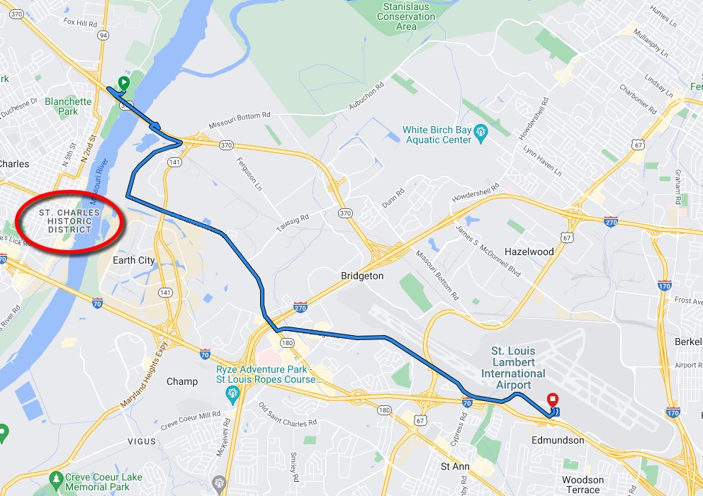
This 9.68 mile route starts on the Katy Trail at Jean Baptist Point DuSable Park near MO-370. The departure point from the Katy Trail is 1.64 miles north-northeast of the St. Charles Trailhead. Starting GPS: 38.801686, -90.469126 (38°48'06.1"N 90°28'08.9"W)
Much of this route follows St. Charles Rock Rd and Natural Bridge Rd. These roads become decreasingly bike-friendly the further east you ride.
Between Lambert Airport and the St. Louis Amtrak Station, you can take the MetroLink for $2.50 per rider (current price, subject to change). Trains are scheduled every 20 minutes (about twenty hours a day, seven days a week). Officially, there is room for six bicycles per train.
Metro: Bike & Ride Metro: Fares & Passes
Directions
0. From the Katy Trail St. Charles Trailhead, ride 1.64 miles north-northeast on the Katy Trail to reach the departure ramp for Jean Baptist Point DuSable Park.
1. Ride across the parking lot and N. River Rd to get onto the ramp for the MO-370 bridge bike lane. Ride over the river, then corkscrew under the highway.
2. The trail coincides briefly with Missouri Bottom Rd, but then Earth City Levee Trail splits off. Ride the trail to St. Charles Rock Rd, about 1.4 miles.
3. Turn east (left) onto St. Charles Rock Rd. Ride about 2.8 miles.
4. Just after traveling under I-270, turn left (east) onto Natural Bridge Rd. Ride about 3.8 miles.
5. When you are in front of Terminal 1, take the exit on the right labeled "Terminal 1 Rental Car Return". Take the middle lane of the ramp, labeled "Terminal 1 Departures", which is the second left. After the underpass, take the ramp up on the left. Unfortunately, there is no bike lane, no shoulder, no sidewalk, just concrete barriers and a single traffic lane. This will put you in front of the building. If you haven't already, dismount here. The first entrance is sensibly labeled "Entry 2". Walk your bike in there.
(I don't know how to make navigation at the airport any more understandable or pleasant. I have lived here my whole life, and I still get confused driving to the airport. If you get lost and need to ask for directions, you are looking for the Terminal 1 Departures drop-off, and you are going to go in through Entry 2, which is marked for the MetroLink Station.)
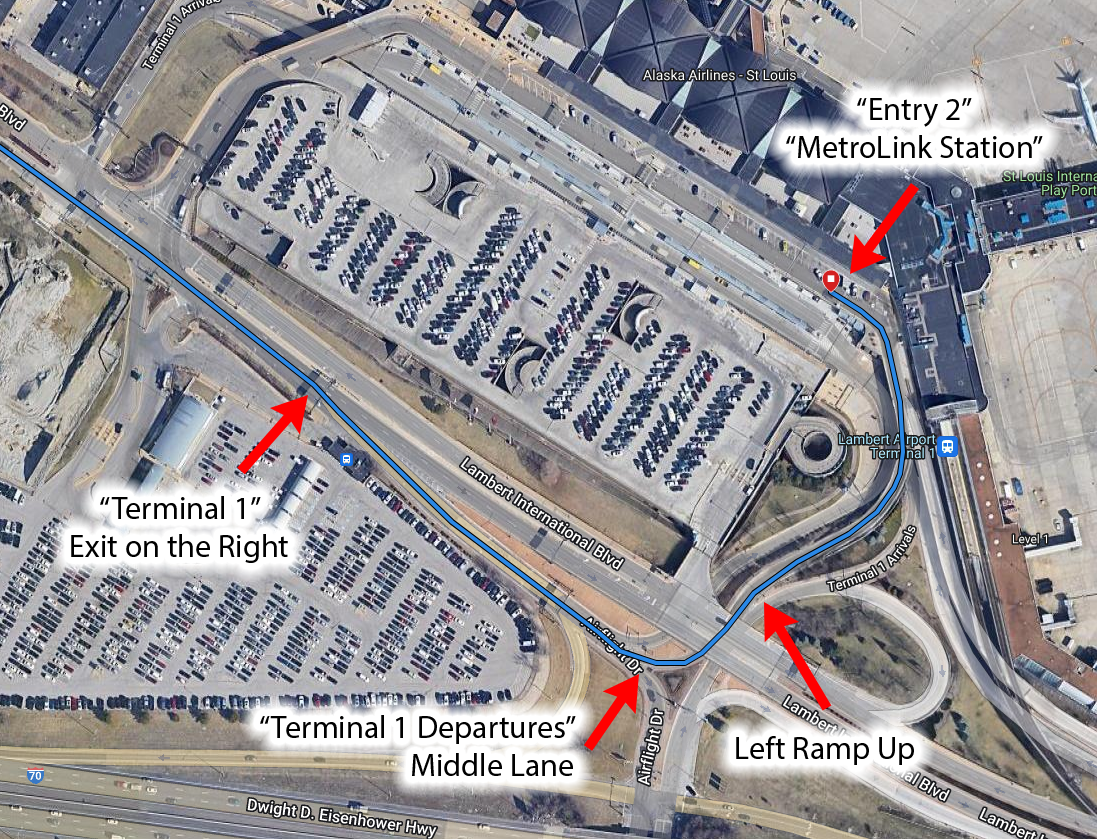
At this point, you are finished cycling. If you are wearing cleats, you might as well make use of a bench and change your shoees.
6. Inside the building, follow the signs for the MetroLink station. Immediately on the right is a short walkway, at the end of which is an escalator, with an elevator behind it. I recommend the elevator. Ride up. Exit the building onto the MetroLink platform.
If you haven't already, pay the MetroLink fare. The "Cash Base Fare - Rail" is the appropriate option at $2.50 per rider. I use the Transit app on my phone, but I believe there is a kiosk at the station.
7. The platform should be marked with three positions to enter with bicycles. At each position, there should be room for two bicycles. This is the end of the line, so you shouldn't have to compete with riders already on board. A train should come along in 20 minutes or less.
8. Ride the train to the Civic Center station. If I'm reading the schedule correctly, it should be about a 31 minute ride, and if I'm reading the map correctly, it should be the 13th stop. The Civic Center station is behind the Amtrak station. At the north end of the platform is a walkway, and in just a few steps to the west, you'll be at the entrance of the Amtrak station.
Potential Improvements
The main problem with these instructions is about how to enter the airport building. The ramp leading up to the Departures entrance is a single lane, concrete barriers on both sides, etc. Is there some other part of the building that is more accessible to cyclists? I wonder if it would be worth contacting someone at the airport and asking them for their recommendation.