
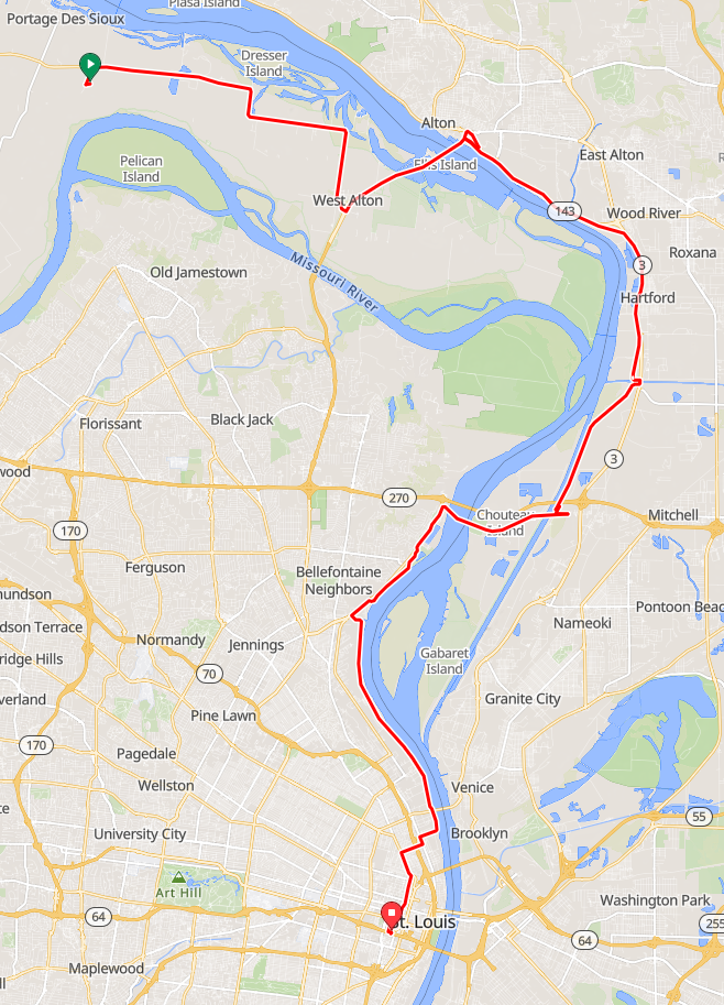
Machens to St. Louis Amtrak via Old Chain of Rocks Bridge
There are other Katy-Amtrak options in the St. Louis area, most of which are shorter.
Courses/Routes for GPS Bicycle Computers
Garmin:
Machens
to St. Louis Amtrak via Old Chain of Rocks Bridge
Ride with GPS:
Machens
to St. Louis Amtrak via Old Chain of Rocks Bridge
Strava:
Machens
to St. Louis Amtrak via Old Chain of Rocks Bridge
40.74 miles, 488 feet ascent
Watch the Whole Ride
I recorded video of this whole route.
Good Old-Fashioned Directions
- From the Machens trailhead, follow the trail northeast to the very end, where a gravel road crosses. Turn left, which follows the railroad tracks for about 200 feet, then turn right to cross the tracks. Take Machens north, about 2100 feet, until you reach the highway (MO-94).
- Turn right (east) onto Hwy 94. Follow the highway until it reaches US-67, about 8.4 miles. Ride across to the north-bound lanes. (There are a couple of gas stations here, where you can buy water or snacks.)
- Turn left (north) on US-67. You'll be on this highway for about 3.4 miles, which includes the ride across the Clark Bridge and the Mississippi River.
- After crossing the Clark Bridge, turn right (east) onto Landmarks Blvd. (IL-143).
- Turn right again (southwest) onto Discovery Parkway. In 2000 feet, the Confluence Trail starts on the left. On the right, Russell Commons Park has bathrooms.
- Turn left onto the Confluence Trail. Follow the trail for 11.6 miles.
- After you pass underneath I-270, there is a ramp down the levee that gets you down to Chouteau Place Rd. / S. Slough Rd.
- Turn right (south) on Chouteau Place Rd. / S. Slough Rd. Follow the road for 900 feet.
- Turn left (east) onto W. Chain of Rocks Rd. This will connect to the road that crosses the bridge in 1400 feet.
- Turn right (west) onto Chain of Rocks Rd. Ride onto the bridge, taking the bike lane across. Continue on this road across the island, about 2 miles.
- Ride straight across the Old Chain of Rocks Bridge parking and up the bridge. Have a look around when you reach the top. Continue on to the other side, about 1 mile.
- On the left, get onto the St. Louis Riverfront Trail, heading south. Follow the trail for 9 miles to Branch Street, right after passing under the McKinley Bridge.
- Turn right (east) onto Branch Street. In a couple of long blocks, about 1800 feet, you'll reach N. Broadway.
- Turn left (south) on N. Broadway. Follow this for three blocks (1000 feet).
- Turn right (east) onto St. Louis Ave. Follow this for 0.5 miles, about seven blocks.
- Turn left (south) on N. Florissant Ave. Take the bike lane. After 0.6 miles, the road will bend around and intersect with N. 14th St.
- Turn right (south) onto N. 14th St. Follow this through downtown St. Louis about 1.25 miles to Clark Ave.
- Turn right (west) onto Clark Ave. Continue for 800 feet.
- Turn left (south) onto S. 16th St. Continue for 800 feet. Enjoy the cobbles.
- Turn left (west) onto Poplar St. Continue for 300 feet. Follow the one-way signs. You have arrived at the St. Louis Gateway Amtrak station.