
Machens to St. Louis Amtrak via McKinley Bridge
There are other Katy-Amtrak options in the St. Louis area, most of which are shorter.
Status: These route files are up to date. I need to edit and post the video.
Courses/Routes for GPS Bicycle Computers
Ride with GPS:
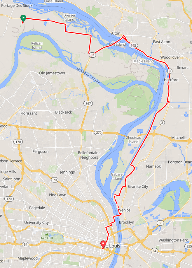
Machens to St. Louis Amtrak via McKinley Bridge
Garmin:
Machens to St. Louis Amtrak via McKinley Bridge
Strava:
Machens to St. Louis Amtrak via McKinley Bridge
37.83 miles, 307 to 491 feet ascent
Good Old-Fashioned Directions
- From the Machens trailhead, follow the trail northeast to the very end, where a gravel road crosses. Turn left, which follows the railroad tracks for about 200 feet, then turn right to cross the tracks. Take Machens north, about 2100 feet, until you reach the highway (MO-94).
- Turn right (east) onto Hwy 94. Follow the highway until it reaches US-67, about 8.4 miles. Ride across to the north-bound lanes. (There are a couple of gas stations here, where you can buy water or snacks.)
- Turn left (north) on US-67. You'll be on this highway for about 3.4 miles, which includes the ride across the Clark Bridge and the Mississippi River.
- Turn left (west) on to Landmarks Blvd. (IL-143). You'll be making another left turn in 750 feet.
- Turn left (south) onto Ridge Street. Cross the tracks, and follow this road until it passes underneath US-67, about 1600 feet. Just after passing under the highway, the Confluence Trail starts on the right.
- Turn right onto the Confluence Trail. All the nerve-wracking stuff is behind you. The trail is fairly easy to follow. After about 16.6 miles, it will end on West 1st Street.
- Turn left (south) onto West 1st Street. Follow this for about 1200 feet.
- Turn right (west) onto Niedringhaus Ave. Continue for about 1200 feet.
- Turn left (southwest) onto Seventh Street. Follow this for about 0.9 miles.
- Turn right (west) onto E Street. Continue for about 2000 feet.
- Just after the curve, turn left (south) onto the bike route, resuming the Confluence Trail. Continue for about 2.2 miles.
- At the McKinley Bridge Roadside Park, there is a bike path on the left that climbs and crosses the McKinley Bridge and the Mississippi River again. Follow this path for about 1.1 miles. The bike ramp bends around to the left and ends at Branch Street (there is no street sign here). Welcome to St. Louis. The St. Louis Riverfront Trail is on your left, but don't take that.
- Instead, turn right (east) onto Branch Street. In a couple of long blocks, about 1800 feet, you'll reach N. Broadway.
- Turn left (south) on N. Broadway. Follow this for three blocks (1000 feet).
- Turn right (east) onto St. Louis Ave. Follow this for 0.5 miles, about seven blocks.
- Turn left (south) on N. Florissant Ave. Take the bike lane. After 0.6 miles, the road will bend around and intersect with N. 14th St.
- Turn right (south) onto N. 14th St. Follow this through downtown St. Louis about 1.25 miles to Clark Ave.
- Turn right (west) onto Clark Ave. Continue for 800 feet.
- Turn left (south) onto S. 16th St. Continue for 800 feet. Enjoy the cobbles.
- Turn left (west) onto Poplar St. Continue for 300 feet. Follow the one-way signs. You have arrived at the St. Louis Gateway Amtrak station.